About the Watch Charts

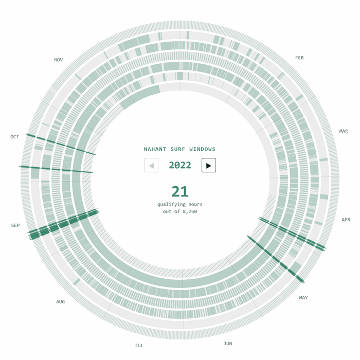
These radial charts visualize every hour (or day) when a set of weather and ocean conditions all align at once. Each concentric ring tracks one condition across the calendar year. The highlighted arcs show where every condition was simultaneously met — the actual windows for surfing or skiing.

Nahant Surf Windows

Seven conditions must align for a viable surf session at Nahant Beach, north of Boston. The chart checks each hour of the year:

  1. Low tide ±1 hour — NOAA tide predictions for station 8443970
  2. Swell ≥ 2 ft — Open-Meteo Marine swell wave height
  3. Offshore or light wind — wind from 210–330° or ≤ 6 knots
  4. Daylight — between sunrise and sunset
  5. No precipitation — zero hourly rainfall
  6. Air > 40°F — 2m air temperature
  7. Water > 45°F — sea surface temperature
Animated radial chart cycling through Nahant surf windows 2022 through 2025
Nahant surf windows, 2022–2025

Explore the interactive surf chart →

Cannon Mountain Powder Days

Three conditions are checked at 9 AM each day for Cannon Mountain in Franconia Notch, NH:

  1. Fresh snow (48h rolling ≥ 8 cm) — ERA5 hourly snowfall, summed over a 48-hour window. ERA5 underestimates mountain snowfall at its ~31 km grid, so 8 cm is a calibrated proxy for roughly 6″+ of real snow.
  2. Deep base (≥ 0.40 m) — ERA5-Land snow depth at ~9 km resolution, better suited for mountain terrain. 0.40 m approximates an established skiable base.
  3. Air > 0°F — 2m air temperature at 9 AM. Too cold and lifts may close or conditions become dangerous.
Animated radial chart cycling through Cannon powder days 2022 through 2025
Cannon powder days, 2022–2025

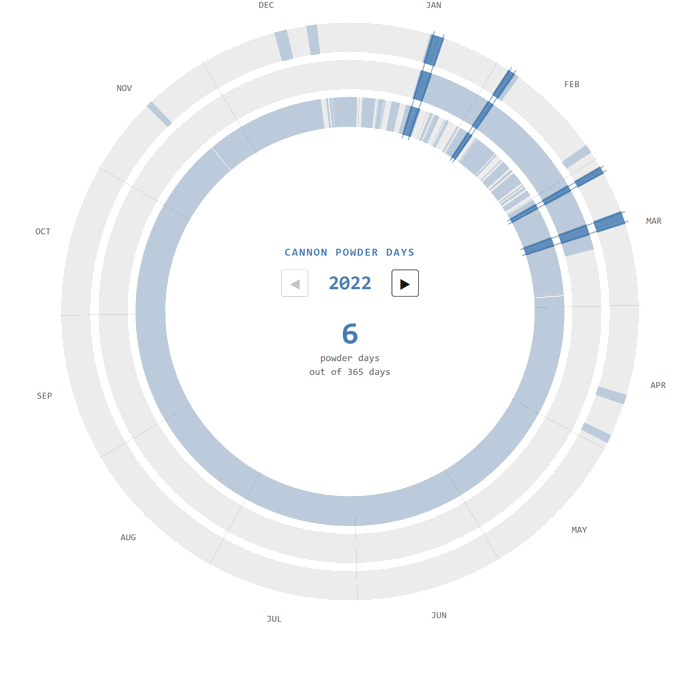
Explore the interactive powder chart →

Seasonal Comparison

A split violin showing the typical seasonal distribution of qualifying days, averaged across 2022–2025. Surf density extends upward (green), ski density extends downward (blue).

Simplified conditions for seasonal comparison: surf qualifying = swell ≥ 2 ft AND water > 45°F AND air > 40°F AND daylight. Ski qualifying = 48h snowfall ≥ 8 cm AND snow depth ≥ 0.40 m AND air > 0°F at 9 AM. Tides, wind, and precipitation are omitted.

Loading data from Open-Meteo...

Data Sources